El Nino and NRC Preparedness
Posted by on February 9, 2016
Branch Chief
Division of Preparedness and Response
 El
Niño is already making itself felt along the West Coast. This
phenomenon occurs every two to seven years. It warms sea surface
temperatures in the eastern-central Pacific Ocean, shifting average sea
level pressure and tropical rainfall in dramatic fashion, and leading to
weather pattern changes over parts of the northern and southern
hemispheres.
El
Niño is already making itself felt along the West Coast. This
phenomenon occurs every two to seven years. It warms sea surface
temperatures in the eastern-central Pacific Ocean, shifting average sea
level pressure and tropical rainfall in dramatic fashion, and leading to
weather pattern changes over parts of the northern and southern
hemispheres.Forecasters expect this year’s El Niño to be one of the strongest ever, based on changes in the sea surface temperatures of the Pacific.
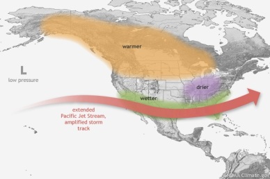
No two El Niño’s are exactly alike, but the pattern generally has these effects:
- Increased rain and snow across California and the southern United States, with less in the Pacific Northwest and in the Ohio and Tennessee valleys
- Milder than normal winter across the northern United States
- More hurricanes than normal in the eastern Pacific and fewer in the Atlantic during hurricane season (June 1 – November 30)
Following the Fukushima events in Japan in 2011, the plants have enhanced their ability to deal with major floods. For example, additional portable safety equipment, such as pumps and generators, is now available both onsite and offsite.
However, El Niño’s storms could block roadways, making it difficult for plant staff to get to the site and impeding public evacuation routes. Plant operators can use other transportation means to get staff and equipment to the site, if needed. And emergency plans have provisions to clear evacuation routes or use alternate routes. These provisions have been tested before, such as during the Missouri River flooding of 2011
The bottom line? California may be unusually soggy this winter, but the NRC does not expect the current El Niño to cause any safety issues for the nation’s nuclear power plants. As always, we remain vigilant and continue to work with other federal agencies on emergency preparedness and incident response, just in case.

No comments:
Post a Comment